Massive 500-Km Land Rupture After Myanmar Earthquake Shocks Scientists
Who? A devastating 7.7-magnitude earthquake struck Myanmar, affecting millions and shocking geologists with an unprecedented 500-kilometer-long land rupture.
What? The earthquake, one of the most powerful in Myanmar’s recorded history, triggered widespread destruction and displaced thousands. Scientists are particularly astounded by the massive surface rupture along the Sagaing Fault, which recorded fault slips of up to five meters.
Where? The epicenter was near Mandalay, Myanmar’s second-largest city. The quake’s impact, however, was felt far beyond the country’s borders, with tremors reported in Thailand, China, and Vietnam.
When? The catastrophe unfolded last Friday, leaving a growing death toll surpassing 3,000 and widespread infrastructural damage.
Why? Myanmar lies along a major tectonic boundary, making it highly vulnerable to seismic activity. This earthquake’s intensity was further amplified by the fault’s supershear nature, where the rupture propagated faster than seismic waves, increasing destruction over a vast area.
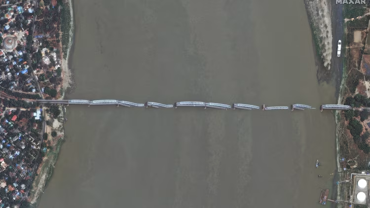
How? Satellite imagery processed by Nahel Belgherze and released by Maxar reveals significant horizontal displacements in both east-west and north-south directions. The highest fault slips were recorded near Mandalay, worsening the devastation in the densely populated area. The military government has declared a temporary ceasefire until April 22 to facilitate humanitarian aid, but relief efforts are hampered by unseasonal rain and ongoing civil unrest.
Scientific Significance and Humanitarian Crisis
The massive 500-kilometer surface rupture has startled geologists, who are now studying its long-term implications. The rupture’s scale suggests enormous tectonic stress build-up, raising concerns over future seismic threats in the region. Meanwhile, millions struggle with food, water, and shelter shortages, and medical aid remains critically insufficient.
The international community is stepping in to provide relief, but efforts are complicated by political instability and challenging terrain. As the crisis unfolds, satellite technology continues to offer crucial data, helping experts assess damage, plan reconstruction, and mitigate future risks.
Way Forward
With Myanmar’s humanitarian needs growing and scientific concerns mounting, immediate international intervention and long-term preparedness strategies are crucial. Governments, NGOs, and research institutions must collaborate to enhance earthquake resilience and provide sustained support for affected communities.
Leave feedback about this